j ![]()

 Navigation: Home
  News
News  Royal National Park News
  Bushfire Alarm Bells – Part 2 ]]>HomeAccommodationAbout BundeenaRoyal National ParkThings to doBundeena MarketsTourism InfoBeachesNews
 Local News
 Development News
 Royal National Park News
 BundeenaInfo NewsEventsReal Estate ReportBusiness DirectoryFerry TimetableBus TimetableMapsPhoto GalleryVideo LibraryClubs & GroupsNewsletterPollsLinksSearchServicesAbout UsContact UsFacebook
  ]]> Bushfire Alarm Bells – Part 2Tuesday, 15 September 2009 ]]>

Part 2 of a discussion paper that looks at the geography of Bundeena in relation to bushfires.
By Phil Clarke
Bundeena Bushfire and Emergency Issues – Discussion Paper
March 2009
TABLE OF CONTENTS
The argument 3
Ten Principles 3
Bundeena’s geography 4
Threatened zone 5
Lack of southern firebreak 5
Eric Street firebreak – the Eastern boundary 6
Clearance needed 6
Widening of fire break 6
Undergrowth clearance for 500 m 7
Wire fencing 7
Hydrants, water sprinklers 7
The Southern Boundary Of Bundeena 8
New Dangers Caused by increased road use and visitors 8
NPWS Bonnie Vale Developments and Great Pacific Drive campaign 8
Consequences in bushfire 8
Emergency services an election issue 9
Water supply 9
Government responsibility 9
Jurisdiction And Monitoring 9
Research 11
Effect of deer culling 11
Patterns of Aboriginal burning 11
Markers for hazard reduction 12
Conclusion 12
Bundeena’s geography
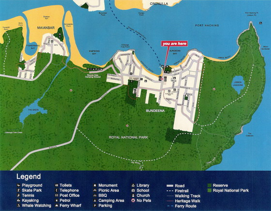
The village of Bundeena when viewed in aerial photographs, such as within “Google Earth,” is triangular in form.
The northern boundary of Bundeena is the sea – the beaches of Hordern’s and Gunyah – extended into parts of Jibbon beach and Bonnie Vale. This forms the base of an inverted triangle, the apex of which is at the end of Bombora Street near the junction of Bombora Street with Eric Street.
Of the remaining two sides of the triangle, the “Eastern” one follows exactly the line of the Eric Street fire break. The third side of the triangle, which we will refer to as the “Southern Boundary of Bundeena”, is formed by a line drawn approximately from the end of the Eric Street firebreak, passing along Spring Gully, past the Oval and Bowling Club, and meeting up with Bonnie Vale beach.

The fire threat to Bundeena therefore primarily consists:
• on the Eastern Boundary from a fire passing through or over the Eric Street Fire break or
• through or over the Southern Boundary, in which there is for the most part currently no real fire break.
The likelihood of fire that threatens all of Bundeena coming from the north, the sea boundary is minimal. Whilst sparks and embers coming from bushfires in areas such as Kurnell may well be blown to Bundeena, threatening fires from such sparks and embers would first result from the ignition of parkland beyond the area of the Bundeena triangle.
Threatened zone
Victorian experience would seem to suggest that, especially with climate change (for whatever reason that exists) the area of immediate threat from bushfires extends at least five hundred metres into human habitation from the boundary of that habitation.
That places almost all of Bundeena within the threatened zone – a fact reflected in the declaration of all of Bundeena as being a “bushfire prone area.” It is ESSENTIAL to our safety in Bundeena that this classification be maintained. It is arguable that unthinking developers may seek to have the Local Council and State government change that classification.
If fire can be prevented from crossing the two park sides of the Bundeena triangle, the safety of Bundeena can be greatly enhanced, allowing the Fire Brigades within Bundeena to deal with spot fires caused by embers and sparks, whilst the general safety of the village can be secured by brigade action along the two park sides of the triangle.
Lack of southern firebreak
Currently a proper firebreak along the southern boundary does not exist. This is a matter that should be rectified immediately. The line can be surveyed and planned immediately and the work carried out this autumn and winter.
The width and nature of firebreaks is extremely important. It is not merely a question of mowing down a line of trees. The break has to be wide enough to limit it being crossed directly by fire from tree to tree, or through undergrowth on one side being ignited by burning undergrowth on the other. The break in the tree cover must be readily capable of being kept clear, and grant access to the fire brigades for hazard control and fire control – including back burning during a fire aimed at containing the major fire and/or securing the village.
Care must also be taken to ensure access to the firebreaks for the fire brigades and that they do not become “wind tunnels” – a horizontal equivalent of lift shafts.
Eric Street firebreak – the Eastern boundary
As can be seen from the aerial photos of Bundeena, the Eric Street firebreak is relatively clear for most of its length but is breached by trees at both the northern Jibbon Beach end and the Bombora Street end, and by occasional trees along its length.
Direct observation shows that it is at best between thirty and thirty five metres wide, and in fact narrower than that along much of its length. Of that thirty metres, frequently half is covered by dry bracken, and vegetation of a highly inflammable nature. Flammable debris is often well over six inches deep in concentrated form with dried bracken and bush up to a metre high.
About fifteen years ago – fortunately just before the 1994 bushfires – Eric street residents took matters into their own hands and, when the ranger’s back was turned, mowed and cleared the firebreak.
Since that time a half hearted attempt has been made on an annual and sometimes twice yearly basis to keep the break clear by sending a tractor down it to clear it. Debris is not however necessarily removed after the tractor passes.
Part 3 – Clearance needed, Widening of fire break and more (click to view)
]]>< Previous Next >[ Back ] All content property of Bundeena Info unless indicated otherwise

